National Agriculture Imagery Program
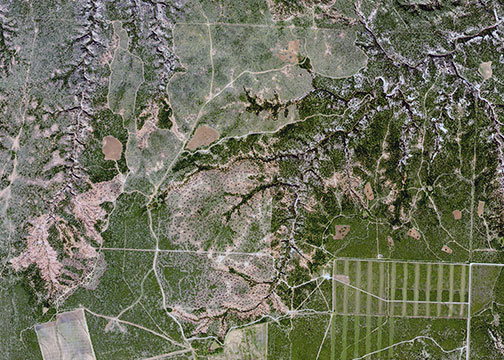
Detail of Impossible Canyon from Hudd digital ortho quadrangles
National Agriculture Imagery Program (NAIP)
The composite NAIP images presented on brazosrivercanyonlands.com cover the four counties of Kent, Scurry, Fisher and Stonewall. The perspective these images offer give an impressive view of the varied topography and landscape of the Brazos River Canyonlands.
NAIP composite maps
- HUDD (Impossible Canyon and Longhorn Valley)
- Hobbs (Branch of Big Rough Creek)
- Tige Canyon (Fisher County)
- Double Mountain
About the program
The National Agriculture Imagery Program (NAIP) is a project of the United States Geological Survey in conjunction with the United States Department of Agriculture.
NAIP acquires imagery during the agricultural growing seasons (spring and summer months for leaf-on coverage) in the continental United States. A primary goal of the NAIP program is to provide digital ortho photography to the public within a year of acquisition.
The primary purpose of NAIP is to acquire peak growing season “leaf on” imagery, and deliver this imagery to United States Department of Agriculture (USDA) County Service Centers in order to maintain Common Land Unit (CLU) boundaries and assist with crop compliance and a multitude of other farm programs.
The the images on brazsorivercanyonlands.com were created using NAIP mosaics with a two meter ground sample distance (GSD) that matches within 10 meters of reference ortho imagery. The reference ortho imagery is mosaicked digital ortho quarter quads (DOQQs) that were used to digitize USDA FSA common land unit boundaries.
The mosaics are generated by compressing digital quarter quadrangle image tiles scanned from natural color positive or color infrared positive aerial film into a single mosaic. The mosaic may cover all or portions of an individual final product. Each individual image tile within the mosaic covers a 3.75 x 3.75 minute quarter quadrangle plus a 300 meter buffer on all four sides. All individual tile images and the resulting mosaic were rectified to the UTM coordinate system, NAD 83 and cast into a single predetermined UTM zone
Digital orthophoto quadrangles
An aerial photograph and an orthophoto or orthoimage may look alike, but there are several important differences that allow an orthophoto to be used like a map. A conventional perspective aerial photograph contains image distortions caused by the tilting of the camera and terrain relief (topography). It does not have a uniform scale. You cannot measure distances on an aerial photograph like you can on a map. An aerial photo is not a map. The effects of tilt and relief are removed from the aerial photograph by a mathematical process called rectification. An orthophoto is a uniform-scale image. Since an orthophoto has a uniform scale, it is possible to measure directly on it like other maps. An orthophoto may serve as a base map onto which other map information may be overlain. A DOQ can be used on-screen to collect, review, and revise other digital data, especially digital line graphs (DLG) and topographic maps. When the DOQ is combined with other digital products, such as digital raster graphics (DRG) or digital elevation models (DEM), the resulting image provides additional visual information for the extraction and revision of base cartographic information
brazosrivercanyonlands.com is published by Jim Watson and licensed
under a Creative Commons Attribution-NonCommercial 4.0 International License.