U. S. Geological Survey
Front side of the Ecoregions of Texas poster
U. S. Geological Survey
Ecoregions of Texas
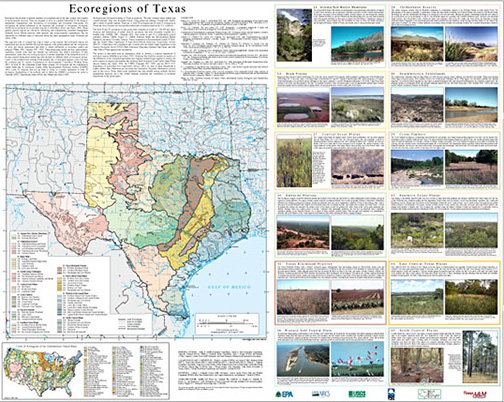
Ecological and biological diversity of Texas is enormous. The state contains barrier islands and coastal lowlands, large river floodplain forests, rolling plains and plateaus, forested hills, deserts, and a variety of aquatic habitats. There are twelve level III ecoregions and 56 level IV ecoregions in Texas and most continue into ecologically similar parts of adjacent states in the U.S. or Mexico.
Ecoregions denote areas of general similarity in ecosystems and in the type, quality, and quantity of environmental resources. They are designed to serve as a spatial framework for the research, assessment, management, and monitoring of ecosystems and ecosystem components. By recognizing the spatial differences in the capacities and potentials of ecosystems, ecoregions stratify the environment by its probable response to disturbance (Bryce and others, 1999). These general purpose regions are critical for structuring and implementing ecosystem management strategies across federal agencies, state agencies, and nongovernment organizations that are responsible for different types of resources within the same geographical areas (Omernik and others, 2000).
This poster is published by the U. S. Geological Survey and made available through the EPA.
U. S. Geological Survey
Ecoregions of Texas
Downloads
Through epa.gov, the EPA makes available printable Adobe PDF files of the “Ecoregions of Texas” map created by the U. S. Geological Survey. Through the links below, you can download high-resolution files of the poster:
- Level IV Ecoregions of Texas (Front side of poster. 3.5 mb)
- Level IV Ecoregions of Texas (Back side of poster. 2.6 mb)
To download only a printable version with the map of Texas and without the full descriptions of each Level IV ecoregion, use the link below:
- Level III & IV Ecoregions of Texas (784 kb)
brazosrivercanyonlands.com is published by Jim Watson and licensed
under a Creative Commons Attribution-NonCommercial 4.0 International License.